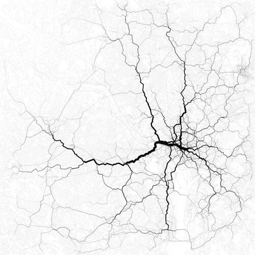
Routing 30,000 randomly-chosen trips through the paths suggested by 10,000 randomly-chosen geotags. These are perhaps the most interesting routes between the endpoints of the trips, even if not necessarily the most likely.
Note that the routes go in & out of the city center, not around it. Makes you wonder who Gov. Bob McDonnell is really working for when he pushes terrible, incredibly expensive ideas like the Outer Beltway.
Check out more of Eric's work on Flickr.
Check out more of Eric's work on Flickr.
2 comments:
Check his analysis on Flickr. I think he's suggesting that these paths mainly follow Metro corridors, which would help explain why the routes are into, rather than around, the city. No?
Have to wonder whether people are more likely to send Tweets while in a Metro (or a passenger in a car) or while driving? Cosnsidering all the solo drivers and the legal bans on emailing (Tweeting) while driving, wouldn't we expect this data to be skewed away from driving?
PS: I support a public transit parallelling the beltway ... consider the traffic from the Bethesda/Tysons area, each day, as an example where perhaps some commuters (and others) could be moved into transit if there were an easier way to move between major 'suburban' centers without going into the city.
Post a Comment